

Measuring Vegetation Management Program Performance Using Machine Learning and Imagery Analysis
One of the more operationally relevant presentations emerging from ROW14 focused on how machine learning and imagery analysis are increasingly being integrated into utility vegetation management programs to improve measurement, forecasting and operational decision making.
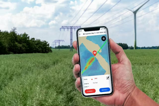
A presentation from Berkeley Electric Cooperative explored how high resolution aerial imagery, ground imagery and machine learning are being used to assess vegetation management program performance across utility rights of way.

The presentation reinforced a broader industry transition currently occurring across utility vegetation management where organisations are increasingly moving beyond simply recording completed work activities and are instead focusing on measurable corridor condition and operational outcomes.
The project discussed during the session combined imagery analysis and machine learning techniques to assess:
• vegetation density,
• plant height,
• species composition,
• pollinator habitat,
• corridor condition,
across managed utility rights of way.
The operational objective was not simply data collection.
The broader goal was to improve visibility across large infrastructure systems and create more measurable vegetation management programs capable of supporting:
• data driven decision making,
• treatment forecasting,
• operational prioritisation,
• defensible reporting,
• long term corridor planning.
One of the more significant themes emerging from the session was the growing ability to measure vegetation management program effectiveness rather than relying purely on historical maintenance records or completed work quantities.
Historically, many vegetation management programs have focused heavily on:
• kilometres treated,
• spray volumes,
• trees removed,
• completed maintenance cycles,
• contractor activity reporting.
While operationally important, those metrics do not necessarily provide clear visibility into actual vegetation condition, treatment performance or long term corridor outcomes.
The use of machine learning and imagery analysis introduces the ability to increasingly measure:
• vegetation response,
• treatment effectiveness,
• regrowth development,
• corridor condition change,
• habitat development,
• vegetation pressure over time.

The presentation also reinforced the growing role of predictive operational systems within infrastructure vegetation management.
By combining historical imagery, current corridor condition and machine learning analysis, utilities may increasingly be able to:
• forecast treatment schedules,
• identify changing vegetation pressure,
• improve intervention timing,
• support condition based maintenance,
• optimise operational expenditure,
• improve long term corridor planning.
The broader implications align strongly with themes discussed throughout the ROW14 series including:
• condition based vegetation management,
• integrated corridor intelligence,
• predictive maintenance systems,
• environmental stewardship,
• vegetation as infrastructure.
Importantly, the presentation reinforced that machine learning and imagery analysis are not replacing operational expertise or field based vegetation management capability.
Their value comes from improving operational visibility, supporting large scale analysis and providing infrastructure organisations with more defensible and measurable decision making frameworks.
Another relevant operational theme throughout the session was the increasing integration between environmental performance and infrastructure management outcomes.
The ability to measure pollinator habitat, species composition and vegetation condition alongside operational vegetation management metrics reflects the broader shift occurring across infrastructure sectors toward:
• ESG accountability,
• environmental stewardship,
• biodiversity monitoring,
• measurable sustainability outcomes,
• defensible reporting systems.
The overall direction of travel across the sector is becoming increasingly clear.
Utility vegetation management is rapidly evolving from broad reactive maintenance programs toward integrated intelligence driven systems supported by machine learning, remote sensing, operational analytics and measurable corridor condition assessment.
That shift is likely to significantly influence how future infrastructure vegetation management programs are planned, measured, prioritised and delivered.

Additional content
VIEW GWS' ADDITIONAL CONTENT TO LEARN MORE ABOUT THE WEED INDUSTRY
Selecting Herbicides Within an Integrated Vegetation Management Program
Effective herbicide selection begins long before a product is chosen. Within an Integrated Vegetation Management (IVM) program, herbicides are selected to support clearly defined management objecti...
Read more
Integrated Vegetation Management: Managing Outcomes, Not Treatments
A vegetation program is not defined by how many times a crew sprays or mows. It is defined by whether the asset is safe, functional and being managed to an agreed standard over time. Integrated Veg...
Read more
Supply disruption is a chance to review, plan and rotate.
When a major product becomes unavailable, it creates an important moment for the industry to pause, review and adapt. The recent supply disruption affecting a key industrial residual herbicide is a...
Read more